The 15 TOP Best Anchorages in Croatia
The Top 15 Best Anchorages in Croatia for Yacht Charters
Anchoring in Croatia reveals stunning water, islands, and coves that inspire awe. With over 1,200 islands, it offers peaceful bays, sandy lagoons, and lively towns with great food and facilities, making your trip both scenic and convenient.
This guide focuses on Dalmatia and highlights 15 of the best anchorages in Croatia for motor yachts, sailing yachts and catamaran charter in Croatia.
- Coordinates for navigation (always confirm on your own charts and plotter)
- Typical depths and seabed
- Wind and swell protection
- Facilities you can expect
- Highlights and nearby attractions
- Specific cautions and limitations
Always verify depths, buoys, and regulations using the latest charts and notices. Staying informed ensures safe navigation and gives you peace of mind during your Croatian adventure.
15 Stunning Dalmatian Bays For Your Yacht Charter
How to read the anchorage snapshots
For each anchorage, you will see:
- 📍 Location – approximate GPS position and island
- ⚓ Depth – typical anchoring range and bottom type
- 💨 Wind protection – what it is good or bad for
- 🛥️ Facilities – buoys, marina, restaurants, shops, fuel, etc.
- 🌄 Highlights – what makes this spot special
- 🚫 Warnings – navigation risks and when to avoid
Anchoring in Croatia is like entering a paradise, with its countless beautiful islands, islets, and lagoons characteristic of the Isles. Sailing yacht charter routes here may seamlessly integrate peaceful isolation with robust cultural and historical appetites, as most are within miles close to each other. As an additional bonus, the Croatian anchorages are sure to catch the attention of charter professionals whose passion takes them beyond the traditional West Mediterranean itineraries.
15 TOP recommended anchorages in Dalmatia, Croatia
As a result, putting together a list of the top 15 anchorages along the Croatian coast is difficult but possible. If you have chosen Dalmatian coast in Croatia as your sailing/yachting itinerary for the following year, here are some advice for your sailing holidays and a list of the 15 best anchorages in Croatia.
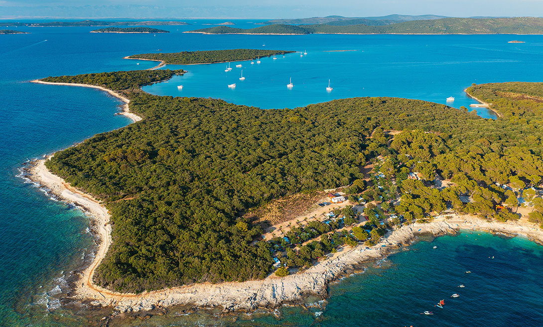
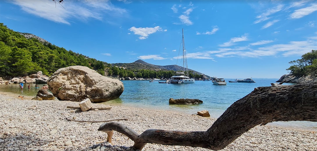
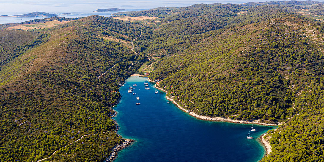
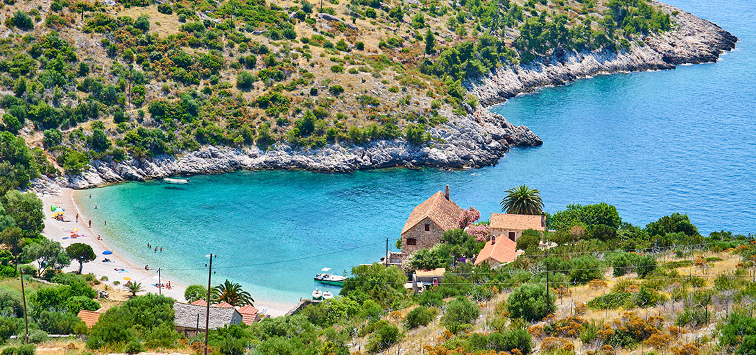
No. 1 - Veli Rat, Dugi Otok (Čuna Bay)
📍 Location: 44°08' N, 14°51' E, Čuna Bay, northwest Dugi Otok.
⚓ Depth: Around 3 to 5 m in most of the anchoring area, soft mud and sand, good holding.
💨 Wind protection: Very well protected from almost all directions inside Čuna Bay, local gusts possible in strong Bura.
🛥️ Facilities: Modern marina in Veli Rat village, mooring buoys, small shops, restaurant and basic services.
🌄 Highlights: Tallest lighthouse on the Adriatic (42 m, built 1849), nearby Saharun sandy beach, pine forests and quiet "hurricane hole" feel.
🚫 Warnings: Shallow marked entrance channel (around 2.5 m), so keep strictly within the buoys; limited anchoring room between moorings; traffic from local boats and charter yachts.
Why is it one of the best anchorages in Croatia?
Veli Rat, at the northwest tip of Dugi Otok, offers a safe, sheltered anchorage often called a 'hurricane hole.' Its all-around protection makes it a trusted spot for a peaceful night before or after crossing open waters, reassuring your confidence in choosing this anchorage. The lighthouse, pine forests and nearby beaches give this anchorage a relaxed, end‑of‑the‑world feel, but you still have the comfort of a small marina and shore facilities if you want them.
No. 2 - Telašćica Nature Park – Tripuljak Bay, Dugi Otok
📍 Location: 43°53' N, 15°09' E, west side of Telašćica Nature Park.
⚓ Depth: 1.5 to 10 m, mostly mud and sand, numerous park mooring buoys.
💨 Wind protection: Well protected from W and N winds; less comfortable in strong Bora and southerlies.
🛥️ Facilities: Mooring buoys maintained by park authority, park rangers, basic rubbish collection; no fuel.
🌄 Highlights: Dramatic sea cliffs, salt lake Mir, marked hiking paths, protected nature park waters.
🚫 Warnings: Park entry and buoy fees apply; less protected from Bora and strong SE winds; can be crowded in high season.
Tripuljak is one of the designated anchorages inside Telašćica Nature Park, an elongated natural bay carved deep into Dugi Otok. From here, you are a short walk from the famous high cliffs and the saltwater Lake Mir, and you get reliable mooring buoys plus good depths for most charter boats. Book or pay the park fee in advance where possible, and keep an eye on the forecast Bora or Jugo (SE) since swell can wrap into parts of the bay.
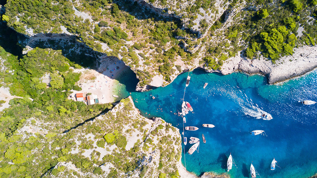
No. 3 - Krknjaši, Drvenik Veli (Blue Lagoon)
📍 Location: 43°26.37' N, 16°10.38' E, east side of Drvenik Veli between islets Veli and Mali Krknjaš.
⚓ Depth: Around 3 m in the main anchoring pool; sandy patches mixed with seagrass and rock; holding can be patchy.
💨 Wind protection: Sheltered from W through N to NE thanks to the two small islands; exposed in strong southerlies and easterlies.
🛥️ Facilities: A few simple beachfront restaurants and bars, some seasonal buoys, no fuel or shops.
🌄 Highlights: Famous Blue Lagoon colour, easy access from Split and Trogir, great swimming and snorkelling, sunset views.
🚫 Warnings: Very busy with excursion boats during the day; shallow and rocky channels, especially between Drvenik Veli and Mali Krknjaš; holding is unreliable in places, so treat overnight anchoring here as "settled weather only"
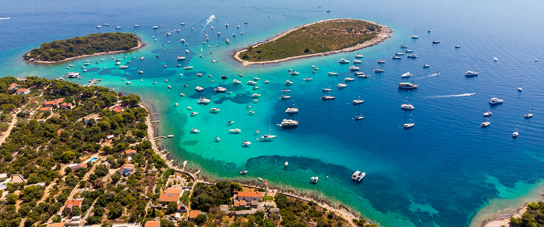
Krknjaši is one of the most photographed anchorages in Central Dalmatia and often tops lists of the best anchorages in Croatia thanks to its luminous turquoise water and sheltered lagoon. Aim to arrive early, drop your hook carefully in a clear sandy patch, and enjoy the day. For overnight stops, only stay if the forecast is calm and always check that your anchor is firmly set.
No. 4 - Bobovišća Bay, Brač
📍 Location: 43°21' N, 16°27' E, west coast of Brač, deep inlet that forks into two arms.
⚓ Depth: 3 to 6 m on moorings in the inner arms, up to around 20 m in the outer bay; mostly mud and sand with good holding.
💨 Wind protection: Very well protected from most directions; some exposure to strong NW winds in the outer part.
🛥️ Facilities: Mooring buoys, small quay, a couple of restaurants and bars, small shop; fuel in nearby Milna (about 2 nm).
🌄 Highlights: Tranquil, fjord‑like setting, pine‑covered slopes, easy overnight stop only about 12 nm from Trogir, historic stone village ashore.
🚫 Warnings: Limited space for free anchoring once buoys and shore lines are in; can be busy on peak summer nights; watch depth near the heads of each arm.
Bobovišća is a classic first- or last-night anchorage for charters starting around Split or Trogir. The bay feels very secure, the water is clear and quiet, and you have enough services for a comfortable stop without losing the small‑village atmosphere.
No. 5 - Borče Bay, Hvar (near Milna)
📍 Location: 43°09' N, 16°28' E, small bay near Milna on the south coast of Hvar.
⚓ Depth: 2 to 10 m; seabed partly sand and partly rock; holding good in sandy areas.
💨 Wind protection: Well protected from most directions; open to strong southerly winds.
🛥️ Facilities: Around 15 mooring buoys linked to a nearby restaurant, seasonal service, no fuel.
🌄 Highlights: Quiet bay close to busier Hvar town area, nice swimming, good base for exploring the south coast of Hvar.
🚫 Warnings: Buoys are typically reserved for restaurant guests and often need booking; limited room for free anchoring; rocks near the shoreline
Borče is a handy "escape" bay when you want peace but still be a short hop from Hvar town or the Pakleni islands. Expect a very relaxed atmosphere in the evening once the dayboats have left, and good protection as long as there are no strong southerlies in the forecast.
No. 6 - Ždrilca, Pakleni Islands (Marinkovac)
📍 Location: 43°09' N, 16°25' E, channel between Marinkovac and Planikovac in the Pakleni Islands, near Hvar.
⚓ Depth: 2 to 12 m; sandy bottom with good holding, but with strong currents in the narrowest part.
💨 Wind protection: Generally well protected from Scirocco and many other winds; open to strong Bura and to heavy traffic swell.
🛥️ Facilities: Mooring buoys, several restaurants, visiting "grocery boat", frequent taxi boats from Hvar town.
🌄 Highlights: Crystal clear water, pebble beaches, easy access to Hvar town, classic Pakleni‑islands scenery.
🚫 Warnings: Strong current in the passage, heavy day traffic, very busy in high season; avoid in strong Bura or local thunderstorms (nevera); shallow patches between nearby islets, so follow charts carefully
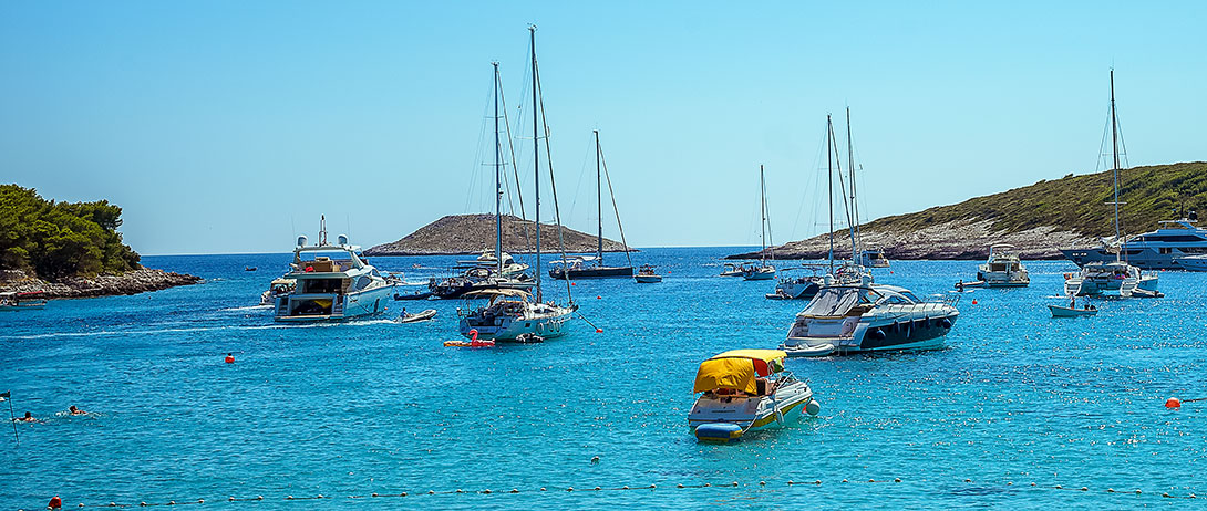
Ždrilca is one of the most popular anchorages near Hvar town, offering good shelter, restaurants, and beach vibes. It works very well as a lunch stop and can be pleasant to overnight in settled conditions, but you must respect the current, traffic, and limited room when the bay is full.
No. 7 - Carpe Diem Beach – Stipanska Bay, Marinkovac (Pakleni)
📍 Location: 43°09'30" N, 16°25'23" E, Stipanska Bay on the south side of Marinkovac, Pakleni Islands.
⚓ Depth: 5 to 10 m in most of the bay, up to around 10 to 12 m; mixed coarse sediment, rock and sand, often best with a line ashore.
💨 Wind protection: Sheltered from many directions but open to S and SE winds, which can bring swell into the bay.
🛥️ Facilities: Carpe Diem Beach Club complex with bar, restaurant, pool, loungers, DJ stage; moorings nearby; frequent taxi boats to Hvar.
🌄 Highlights: Iconic nightlife spot, full moon parties, pine forest backdrop and stylish beach‑club setting.
🚫 Warnings: Loud until late in peak season; open to S and SE winds, so not ideal in Jugo; busy boat traffic; take care swimming at night when tenders and taxi boats move quickly.
Stipanska is where you come when you want party anchoring rather than total peace. Many charter guests combine a quiet morning somewhere else with an afternoon and night at Carpe Diem Beach, then move to a calmer anchorage for the following night if the forecast turns.
No. 8 - Porat Bay (Biševska Luka), Biševo
📍 Location: 42°59' N, 16°00' E, northwest side of Biševo, known as Bisevska Luka or Porat.
⚓ Depth: Around 5 to 10 m in the inner part on sand, shallowing to about 1.5 m near the beach; good holding in sand.
💨 Wind protection: Good shelter from N, E and S winds; exposed and uncomfortable in strong W and SW winds.
🛥️ Facilities: Simple beach restaurant or konoba in season, walking path to the island interior; no fuel or shops.
🌄 Highlights: Beautiful sandy beach, pine forest shade, access to Blue Cave (Modra špilja) and other famous sea caves of Biševo.
🚫 Warnings: Avoid with forecast W or SW; small bay, so space is limited; anchoring too close to the beach is unsafe and may be restricted; heavy day traffic from cave tours
Porat is often considered one of the most scenic anchorages in Croatia thanks to its sandy beach and dramatic cliffs. It is also the best jumping‑off point for visiting the Blue Cave and Monk Seal Cave by organised tour or dinghy when permitted.
Plan your arrival for morning or late afternoon to avoid peak cave‑tour crowds, and always leave if a strong westerly wind change is expected.
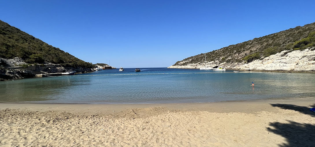
No. 9 - Stončica Bay, Vis
📍 Location: 43°03' N, 16°14' E, northeast tip of Vis island.
⚓ Depth: 2 to 30 m; mooring field in the central part; very shallow (0.5 to 2 m) in the southern shallow area; sandy bottom with good holding.
💨 Wind protection: Well protected from all winds except those from the north; generally calm in summer.
🛥️ Facilities: About 24 mooring buoys, seasonal restaurant, beach, lighthouse nearby; fuel in Vis town about 4 nm away.
🌄 Highlights: Lovely family-friendly beach, shallow sandy swimming area, green surroundings, good access to Vis town by short sail.
🚫 Warnings: Anchoring on your own anchor is prohibited within 150 m seaward of the mooring field; it can fill quickly on peak nights; oversee depths when approaching the shallows.
Stončica offers a good balance of shelter, services and natural beauty. It is often the first choice overnight anchorage on Vis for crews who want to be near town but prefer a quieter bay with a beach and a konoba right on the water.
Still, Stoncica is protected from all winds, including the bura wind, and is the first choice for sailors and yachters who want to enjoy and relax close to civilisation. About 15 homes owned by locals and rented out are in Stoncica bay.
In the bay, a cute restaurant serves a wide range of fresh dishes cooked on the grill and under the bell (peka)
(check this blog post to learn more about traditional Croatian food and Peka). Catch-of-the-day specials, other seafood, and meat options are available. Boaters and sailors go to Stoncica bay because it is a gourmet Mecca surrounded by beautiful nature.
No. 10 - Stiniva Bay, Vis
📍 Location: 43°01' N, 16°11' E, south coast of Vis, narrow cove under high cliffs (wikidata.org).
⚓ Depth: About 10 to 15 m at the anchoring point outside the cove entrance, with firm seabed; steep‑to shores.
💨 Wind protection: The inner cove is well sheltered from many directions but very small; the outer anchorage is open to swell from S and SW and affected by traffic.
🛥️ Facilities: Simple beach bar in season, no formal moorings or marina.
🌄 Highlights: Famous collapsed cave entrance, amphitheatre‑like cliffs and pebble beach, voted one of Europe's best beaches.
🚫 Warnings: Not recommended as an overnight anchorage; very tight space inside; risk from boat traffic and propellers when crowded; cliff jumping is dangerous despite its popularity.
Stiniva is an essential daytime stop on any Vis itinerary and often appears in international rankings of Croatia's most beautiful beaches. The safest approach for charter boats is to anchor outside in good holding, then go in with a tender or swim through the narrow gap, always keeping an eye on traffic and staying well away from moving propellers. Treat this as an anchorage only for lunch and swimming.
In 2016, Stiniva wasn't named one of the best anchorages in Croatia, but it was named The Best Beach in Europe, making it twice as popular and bringing twice as many people. Even so, it is still a special part of the Croatian coast. If you are brave enough to walk down a steep and narrow path, you can get there on foot. Otherwise, it is a boater's paradise. Jumping off the cliffs has become popular, but be aware that it is dangerous.
No. 11 - Budikovac Bay (Blue Lagoon), Budikovac
📍 Location: 43°01' N, 16°14' E, west side of Veli Budikovac, southeast of Vis.
⚓ Depth: Very shallow, roughly 1 to 4 m; patches of sand and rock; some areas only suitable for shoal draft boats; good holding in sand but limited swing room.
💨 Wind protection: Well protected from E winds; partly sheltered from W by Mali Budikovac and the Sanak reef; open to strong S and SW winds.
🛥️ Facilities: A small seasonal restaurant or konoba, a few buoys close together, no fuel or shops.
🌄 Highlights: Famous turquoise Blue Lagoon of Budikovac, sandy seabed, clear water for snorkelling, intimate island setting with almost no permanent inhabitants
🚫 Warnings: Very shallow and tight; extreme care needed when entering between Mali Budikovac and Budikovac; some rocks near the Budikovac side of the channel; bay can be packed with excursion boats; overnight stay only in very settled weather and with careful depth checks
Budikovac's lagoon is a must‑see for many sailors in Central Dalmatia and competes strongly for the title of "most beautiful anchorage in Croatia" for its water colour alone. Just remember that it is a shallow, small and fragile bay, best treated as a daytime stop with conservative anchoring practices.
If you plan to go to Budikovac Bay, remember to bring your goggles to snorkel, as this is one of the Adriatic's most beautiful lagoons. You'll fall in love with a sandy beach, clear water, a quiet night, and a few happy swimmers during the day. You can also go to the Green Cave, less than one nautical mile away, or Bisevo Island's well-known Blue Cave, about ten nautical miles away. And, of course, no trip is complete without eating at the tiny restaurant owned and operated by a single resident of the area.
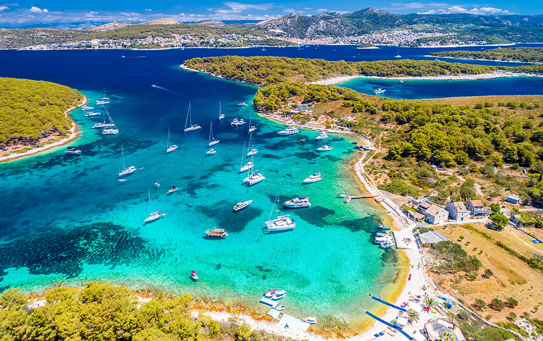
No. 12 - Palmižana, Pakleni Islands (Sv. Klement)
📍 Location: 43°09.5' N, 16°23.8' E, Palmižana Bay on the northeast coast of St. Clement (Sv. Klement), Pakleni Islands.
⚓ Depth: Around 5 to 10 m in the anchorage area; sand, rocks and seagrass; ACI Marina Palmižana has dredged berths of adequate depth for most charter yachts.
💨 Wind protection: Marina and bay are well protected from most winds, but can see swell in strong S and SW; some exposure to N and NE for the marina entrance.
🛥️ Facilities: ACI marina with around 160 to 200 berths, water, power, showers, restaurants, small shops; additional anchoring possibilities nearby; fuel available in Hvar town, about 2.5 nm away.
🌄 Highlights: Lush botanical gardens and pine forests, vibrant restaurant scene, short water‑taxi hop to Hvar town, considered one of the most beautiful marinas in the Adriatic.
🚫 Warnings: Very popular and often fully booked in summer, especially during events in Hvar; some swell in strong southerlies; careful navigation required around the Baba rock off the entrance.
Palmižana is the go‑to base for visiting Hvar by yacht. It shelters you, complete marina services and a relaxed island atmosphere with several excellent konobas and beach bars, while keeping you only a short dinghy or taxi‑boat ride from Hvar's nightlife and old town walls.
No. 13 - Pribinja Bay, Hvar
📍 Location: 43°11' N, 16°26' E, north side of Hvar island, just west of Hvar town.
⚓ Depth: 1 to 10 m; mostly sand and rock; a combination of moorings and anchoring in parts of the bay.
💨 Wind protection: Good all‑round shelter in normal summer conditions; local gusts in Bura possible, but the bay is generally considered well protected.
🛥️ Facilities: A few mooring buoys, two popular waterfront taverns, seasonal services; Hvar town, fuel and more shops about 1.3 nm away.
🌄 Highlights: Pine‑fringed coves, quieter than Pakleni anchorages but still close to Hvar, good swimming and sunset views.
🚫 Warnings: Reports of dense restaurant buoys and limited space for free anchoring; local operators may restrict anchoring between buoys; can be full in July and August.
Pribinja is ideal if you want a calmer alternative to Hvar port or Palmižana, but still be just a dinghy ride from the town. Book buoys in advance in high season when possible, and always respect local buoy fields and restrictions.
No. 14 - Lovišće Bay, Šćedro Island
📍 Location: Approximately 43°05.6' N, 16°42.0' E, north side of Šćedro between Hvar and Korčula.
⚓ Depth: Typically 4 to 10 m, depending on which arm of the bay you choose; sandy and muddy patches with good holding.
💨 Wind protection: Very well protected from most winds; arms of the bay allow you to choose shelter depending on direction; some exposure to strong N in the outer parts.
🛥️ Facilities: Several mooring buoys associated with small family‑run konobas, simple jetties for tenders, walking paths ashore; no fuel or large shops.
🌄 Highlights: Quiet island with almost no permanent population, traditional konobas, very dark skies for stargazing, good swimming and short hikes.
🚫 Warnings: Limited supplies ashore; some buoys are private or reserved for restaurant guests; approach with care at night due to nearby shoals and unlit rocks
Lovišće is one of those anchorages that charter skippers rave about later: calm, green and still relatively undeveloped. It is ideally positioned as an overnight stop on a route between Hvar and Korčula or Lastovo. Each of the four arms of the bay is suitable for anchoring and has its little restaurant serving traditional food. A spot to swim, unwind, dine, and even explore the island on foot.
No. 15 - Lučice Bay, Brač
📍 Location: 43°18'20" N, 16°27'04" E, south coast of Brač, a few kilometres west of the passage Splitska Vrata.
⚓ Depth: Roughly 5 to 20 m; deeper in the central pool; shallower near the western arm; seabed a mix of sand and rock with mooring chains and lines laid on the bottom.
💨 Wind protection: Western arm exceptionally well protected from most winds; other arms more exposed to SW swells.
🛥️ Facilities: Mooring buoys operated by a restaurant, seasonal services; no fuel; small jetty for dinghies.
🌄 Highlights: Attractive, tree‑lined bay split into three arms, handy staging point en route to Korčula, Lastovo or Vis, clear water and good snorkelling.
🚫 Warnings: Numerous mooring lines and chains on the seabed, so it is easy to foul your anchor if you try to free‑anchor near the buoys; limited swinging room; stern line to shore often required.
Lučice works very well as a transit anchorage when routing south from the Split area toward the outer islands. Aim for the better‑protected western arm if you can secure a buoy, and be meticulous with your anchor placement if you choose to free‑anchor on the fringes.
Here is a compact comparison table for the article so readers can quickly scan Depth, shelter and facilities for all 15 anchorages:
Summarized Compact Comparison Table
*Depths, shelter descriptions and facilities in this table are approximate summaries based on a mix of nautical guides and cruising resources (Navily, mySea, ACI and official park and tourism sites).
Conclusion: However, there are many reasons sailors and yachters choose to spend their sailing holidays in Croatia. In Croatia, you can find more than 1,200 islands, islets, rocks, and reefs. And over half of them are uninhabitable, so sailors can enjoy beautiful beaches and nature that hasn't been touched. That's one of the reasons why there are so many options to find more than only 15 best anchorages in Croatia.
Quick anchoring tips for Croatia
- Respect protected areas: Many of the best anchorages in Croatia sit inside nature parks or near seagrass meadows (Posidonia). Avoid anchoring in marked protected zones and consider using buoys where provided.
- Check local rules: Zones of special protection, national park tickets, and local buoy concessions change regularly. Check the latest info through official park sites, harbour masters or reputable cruising guides.
- Allow for Bora and Jugo: Croatian anchorages often have very different behaviour in NE Bura versus SE Jugo. Build your itinerary and overnight choices around reliable shelter for the expected wind, not just the prettiest photo.
- Use plenty of chain: Crowded bays, gusty winds and mixed seabeds reward generous scope and a well‑set anchor. Combine chain length with depth and conditions rather than following a single fixed ratio.